The Paradox of the Blizzard: Why a Warmer Planet Creates Heavier Snow
It seems counter-intuitive, but a warmer planet doesn't mean the end of snow. It means the beginning of supercharged storms. Here is the physics behind the paradox.
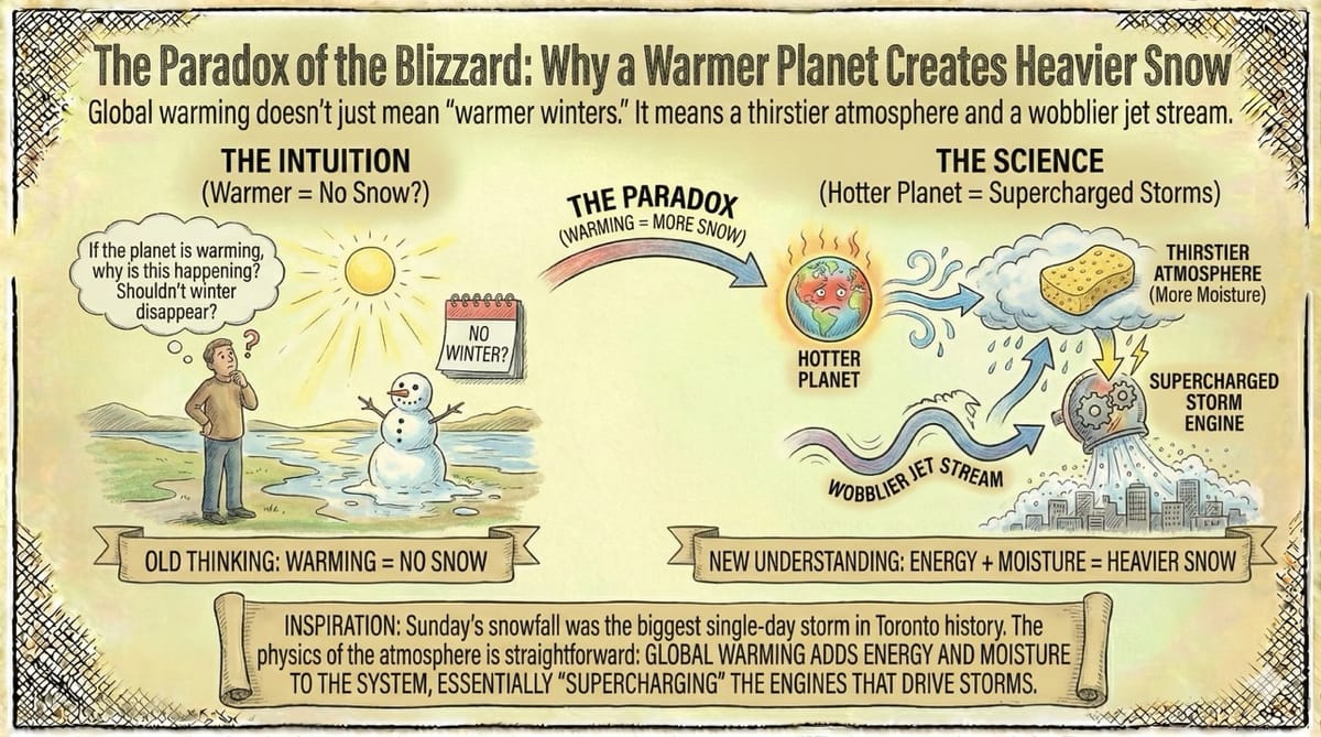
Global warming doesn't just mean "warmer winters." It means a thirstier atmosphere and a wobblier jet stream.
Inspiration: Sunday's snowfall was the biggest single-day storm in Toronto history. Standing in the cold, it’s easy to ask: "If the planet is warming, why is this happening?"
It seems counter-intuitive. If the planet is getting hotter, shouldn't winter disappear?
But the physics of the atmosphere is straightforward. Global warming doesn't just mean "warmer winters everywhere"; it adds energy and moisture to the system, essentially "supercharging" the engines that drive storms.
Here is the scientific breakdown of why a hotter planet produces deeper snow.
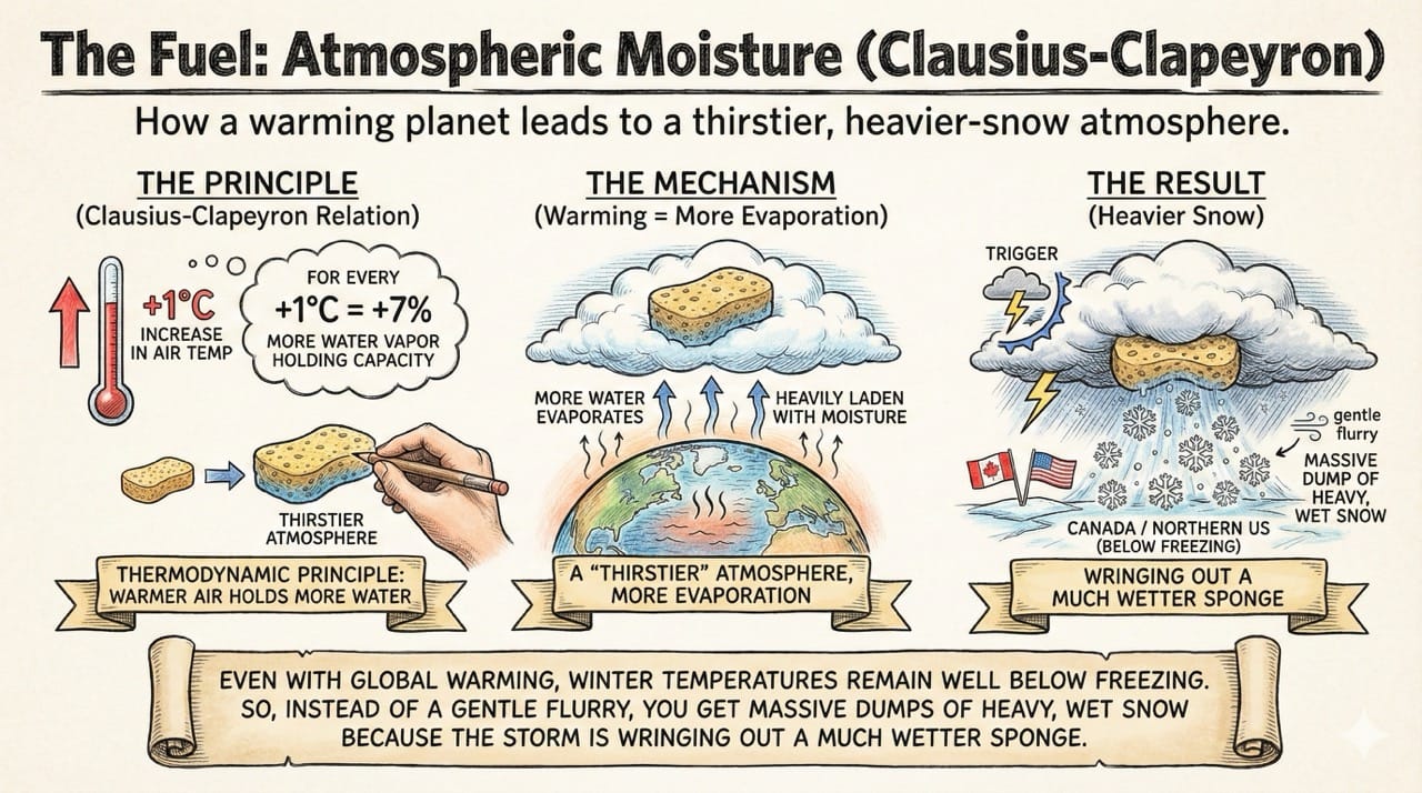
1. The Fuel: Atmospheric Moisture (Clausius-Clapeyron)
The most direct link is a thermodynamic principle called the Clausius-Clapeyron relation.
It states that for every$1^\circ C$increase in air temperature, the atmosphere can hold approximately 7% more water vapor.
The Mechanism: As the oceans and lower atmosphere warm, more water evaporates. This creates a "thirstier" atmosphere that is heavily laden with moisture.
The Result: When a storm system triggers that moisture to condense (turn into clouds and precipitation), there is significantly more water available to fall.
Even with global warming, winter temperatures in Canada and the Northern US remain well below freezing. So, instead of a gentle flurry, you get massive dumps of heavy, wet snow because the storm is wringing out a much wetter sponge.
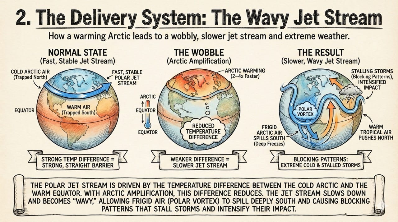
2. The Delivery System: The Wavy Jet Stream
This is perhaps the most critical factor for cold extremes.
The Polar Jet Stream is a river of fast-moving air that acts as a barrier, keeping cold Arctic air trapped up North and warm air down South. Its speed is driven by the temperature difference between the cold Arctic and the warm Equator.
The Wobble: The Arctic is warming 2–4 times faster than the rest of the planet (Arctic Amplification). This reduces the temperature difference.
With a weaker difference, the Jet Stream slows down. Like a slow-moving river, it starts to meander and get "wavy."
These large waves allow frigid Arctic air (the Polar Vortex) to spill deeply into southern latitudes (causing deep freezes) while simultaneously pushing warm tropical air unusually far north. These "blocking patterns" cause storms to stall over one area for days, intensifying their impact.
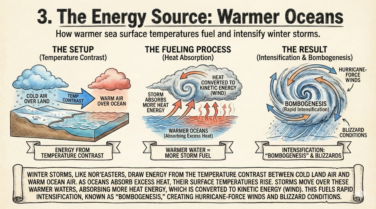
3. The Energy Source: Warmer Oceans
Winter storms, such as Nor'easters or "atmospheric rivers," draw their energy from the temperature contrast between the cold air over land and the warm air over the ocean.
As the oceans absorb the majority of Earth's excess heat, sea surface temperatures rise. When storms move over these warmer waters, they absorb more heat energy.
Intensification: This heat is converted into kinetic energy (wind) through the release of latent heat. A warmer Atlantic Ocean provides the fuel for Nor'easters to rapidly intensify (a process known as "bombogenesis"), creating hurricane-force winds and blizzard conditions.
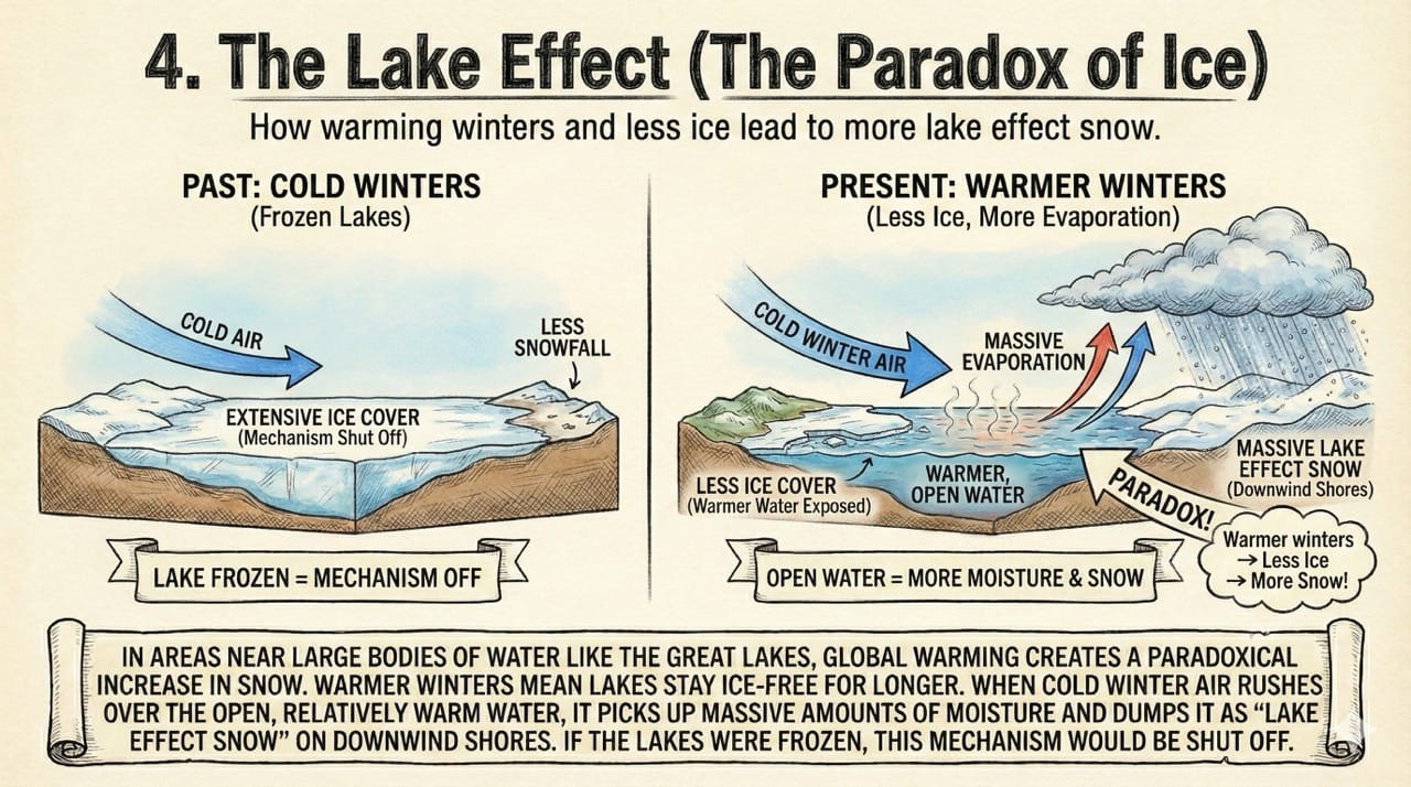
4. The Lake Effect (The Paradox of Ice)
In areas near large bodies of water (like the Great Lakes), global warming creates a paradoxical increase in snow.
Less Ice Cover: Warmer winters mean lakes stay ice-free for longer.
More Evaporation: When cold winter air eventually rushes over the open, relatively warm water, it picks up massive amounts of moisture and dumps it as "lake effect snow" on the downwind shores.
If the lakes were frozen (as they might have been in colder decades), this mechanism would be shut off.
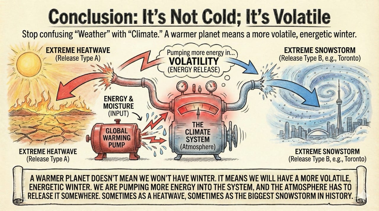
Conclusion: It’s Not Cold; It’s Volatile
We need to stop confusing "Weather" with "Climate."
A warmer planet doesn't mean we won't have winter. It means we will have a more volatile, energetic winter. We are pumping more energy into the system, and the atmosphere has to release it somewhere.
Sometimes that release looks like a heatwave. Sometimes, it looks like the biggest snowstorm in Toronto's history.